Urban Talks
  • Home
  • Maps
    • Vijayawada Land Prices Map
    • Amaravati Land Prices Map
  • Tutorials
    • GIS
  • Food
  • About Us

Buzz is on

GIS0012-2018.07.11-Adjusting-features-in-ArcGIS-using-Spatial-Adjustment-0.png
ARCGIS

GIS0013 2018.07.11 Adjusting features in ArcGIS using Spatial Adjustment

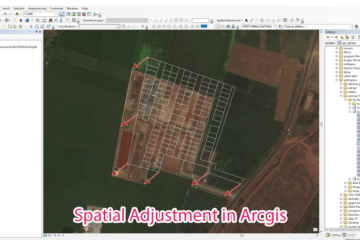
Summary – Adjusting features in ArcGIS using Spatial Adjustment. Adjust features in Arcgis using Spatial Adjustment tool. Two Steps: Configure Spatial Adjustment. Perform Adjustment. Procedure Configure Spatial Adjustment Start Editing from editor menu. Right click and enable Spatial Adjustment Tools. Read more…

By Sandy, 7 yearsSeptember 7, 2018 ago
TECH0003-2018.7.19-Host-Two-Webapps-on-Same-Server-Same-Port-Different-Domain-Name-Using-NGINX-0
Software

TECH0003 Install NGINX as a service on Windows

Summary – Install NGINX as a service on Windows. | NGINX | Host Two Web Apps on Same Server Same Port Different Domain Name Using NGINX. Two Steps: Download Nginx and NSSM. Use NSSM to install NGINX as  a service. Read more…

By Sandy, 8 yearsJuly 19, 2018 ago
TECH0002-2018.1.7-Host-Two-Webapps-on-Same-Server-Same-Port-Different-Domain-Name-Using-NGINX-0
Software

TECH0002 Host Two Web Apps on Same Server Same Port Different Domain Name Using NGINX

Summary – Host Two Web Apps on Same Server Same Port Different Domain Name Using NGINX. | NGINX | Host Two Web Apps on Same Server Same Port Different Domain Name Using NGINX. Two Steps: Start Your two or more Read more…

By Sandy, 8 yearsJuly 18, 2018 ago
GIS0012-2018.07.11-Connect-Qgis-to-Postgis-Database-3.png
GIS

GIS0012 Connect Qgis to Postgis Database and Edit Data Layers

Summary – Connect Qgis to Postgis Database and Edit Data Layers. Instructions provided describe how to Connect Qgis to Postgis Database and Edit Data Layers. Two Steps: Connect Postgis Database to Qgis. Push back the edited data layer to Database. Read more…

By Sandy, 8 yearsJuly 11, 2018 ago
GIS0011-2018.03.10-Get-Elevation-of-Points-using-Dem-files-0
ARCGIS

GIS0011 Get Elevation of Points using Dem files

Summary – Get Elevation of Points using Dem file. Instructions provided describe how to Get Elevation of Points using Dem files. Two Steps: Interpolate 3d for the layer Using a dem file. Get Elevations to attribute table using Calculate Geometry tool. Read more…

By Ritwika Dasgupta, 8 yearsMarch 1, 2018 ago
GIS0009-2018.02.18-Origin-Destination-Matrix-In-Gis-The-Easy-Way-feature-image
ARCGIS

Origin Destination Matrix In Gis The Easy Way

Summary – Plotting Origin Destination Matrix In Gis The Easy Way. Instructions provided describe how to Plot Origin Destination matrix in Gis in an easy way. Two Steps: Prepare the Data needed for Plotting in GIS. Import data into QGIS Read more…

By Sandy, 8 yearsFebruary 18, 2018 ago
GIS0009-2018.02.17-GIS-Features-Updation-using-Autocad-featured-image
ARCGIS

Update GIS Features using AutocadMap

Summary – Update GIS Features using AutocadMap. Instructions provided describe how to update GIS features using AutocadMap , in the tutorial AutocadMap 3D has been used to update a Shapefile. We all miss the good  cad interface when dealing with Read more…

By Sandy, 8 yearsFebruary 17, 2018 ago
Food

Introduction to My Food Journey

There’s no love sincere than the love for FOOD!! My love for food was always there somewhere. My childhood memories are full of MasterChef episodes and various other cooking shows and I loved eating outside since always. But when I Read more…

By Ritwika Dasgupta, 8 yearsFebruary 15, 2018 ago
Sample-of-Expression-of-Interest-in-a-Newspaper
Project Management

Sample Format for Expression of Interest and Minutes of Meeting

Sample Format for Expression of Interest in a Newspaper Download Editable Version Sample Notice inviting expression of interest Download Editable Version Sample Minutes of a Pre-Bid Meeting Download Editable Version

By Sandy, 8 yearsJanuary 24, 2018 ago
Drinking-water-supply-scheme-jaipur
Environment

Overview of Urban Water Management in Jaipur City

Jaipur water management at urban level is discussed below Importance of water in Indian cities as a resource Water is a fundamental natural resource to life and food security it is a finite and vulnerable resource, essential to sustain life, development and Read more…

By Sandy, 8 yearsJanuary 9, 2018 ago

Posts pagination

Previous 1 2 3 4 Next
ads by google
Recent Posts
  • Parking Development Cost Calculator by Krishna Kumar Srivastava
  • GIS0016 2019.09.04 Landuse Pixelation to Identify Major Landuse by Area in each Grid
  • MAP-5 Jaipur City Map 06-05-2019
Recent Comments
  • [ QGIS ] – Origin Destination Matrix – The Easy Way (QGIS 2.x and QGIS 3.x) | All Around GIS on Origin Destination Matrix In Gis The Easy Way
  • Sandeep Kumar on Mapping Damage to Structures From Hurricane Harvey in Harris County (Houston)
  • Sandeep Kumar on How To: Create a Ground water level map for India in arcgis using data downloaded from CGWD
Archives
  • June 2021
  • September 2019
  • May 2019
  • April 2019
  • November 2018
  • October 2018
  • September 2018
  • July 2018
  • March 2018
  • February 2018
  • January 2018
  • December 2017
  • November 2017
  • October 2017
Categories
  • ARCGIS
  • Autocad
  • City Maps
  • DATA SCIENCE
  • Drones/UAV
  • Environment
  • Food
  • GIS
  • Landuse
  • Maps
  • Project Management
  • python
  • QGIS
  • Software
  • Transport
  • TUTORIALS
  • Uncategorized
  • Urban Planning
  • Water
Calender for posts
March 2026
S M T W T F S
1234567
891011121314
15161718192021
22232425262728
293031  
« Jun    

  • Home
  • Maps
  • Tutorials
  • Food
  • About Us
Hestia | Developed by ThemeIsle