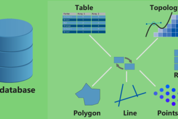
Urban Talks
  • Home
  • Maps
    • Vijayawada Land Prices Map
    • Amaravati Land Prices Map
  • Tutorials
    • GIS
  • Food
  • About Us

October 2017

ARCGIS

How To: Create a Ground water level map for India in arcgis using data downloaded from CGWD

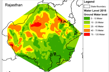
Summary – Create a Ground water level map for India in arcgis Instructions provided describe how to Create a Ground water level map for India in arcgis using CGWD data downloaded from this page for full india http://www.india-wris.nrsc.gov.in/GWL/GWL.html Three Steps: Download data from CWD data portal Prepare data for making map Read more…

By Sandy, 5 years5 years ago
ARCGIS

How To: Create a Geodatabase in ArcGis and import files in it

Summary – Create a Geodatabase in ArcGis and import files in it Instructions provided describe how to Create a Geodatabase in ArcGis and import files in it Procedure Create a new geo-database Click on Catalog from sidebar or windows menu. Right click on the folder from catalog where you want Read more…

By Sandy, 5 years ago
ARCGIS

How To: Repair data source Fix data error in Arcgis file

Summary – Repair data source Fix data error in Arcgis file Instructions provided describe how to Repair data source Fix data error in Arcgis file Procedure Open the Repair Data Source Dialog Box Open Table of Contents pane from side menu or Windows menu. Right click on the layer of Read more…

By Sandy, 5 years ago
ARCGIS

How To: Select features in a shapefile by using select by Location tool with Interested Area in Arcgis

Summary – Select features in a shapefile using select by Location tool with Interested Area in Arcgis Instructions provided describe how to Select features in a shapefile by using select by Location tool with Interested Area in Arcgis Procedure Select features by using select by Location tool From Selection menu Read more…

By Sandy, 5 years5 years ago
ARCGIS

How To: Select features using Select by Attribute (data column) in a shapefile in Arcgis

Summary – Select features using Select by Attribute Instructions provided describe how to Select features using Select by Attribute (data column) in a shapefile in Arcgis. Procedure Select features by Select by Attribute tool From Selection menu click on From Selection menu click on  select by Attribute option. Select the Layer which Read more…

By Sandy, 5 years5 years ago
ARCGIS

How To: Convert selected features to a shapefile in Arcgis

Summary Convert selected features to a shapefile Instructions provided describe how to convert the selected features of a layer to a new shapefile in ArcGis(ArcMap) by using the Export Data feature. Two Steps: Selecting Features Exporting Features Procedure Select features by manually clicking on them Remove polygon fill from Interested  Area Read more…

By Sandy, 5 years5 years ago
ads by google
Popular Posts
  • Start editing on new Shapefile Digitization of data from... Summary - Create shapefiles or geotiff from a wms lin... 19 views | by Sandy | posted on November 9, 2017
  • My College submission sheet for Landuse Transition Matrix Landuse Modeling for Chan... Summary - Create a Transition Matrix for Landuse Chan... 6 views | by Sandy | posted on November 9, 2017
  • MAP-5 Jaipur City Map 06-... Jaipur City Map Download Data Used in this... 5 views | by Sandy | posted on May 6, 2019
  • MAP-4 Kanpur City Map 28-... Kanpur City Map Download Data Used in this... 4 views | by Sandy | posted on April 28, 2019
  • How To: Create a Ground w... Summary - Create a Ground water level map for India i... 3 views | by Sandy | posted on October 15, 2017
Recent Posts
  • Parking Development Cost Calculator by Krishna Kumar Srivastava
  • GIS0016 2019.09.04 Landuse Pixelation to Identify Major Landuse by Area in each Grid
  • MAP-5 Jaipur City Map 06-05-2019
Recent Comments
  • [ QGIS ] – Origin Destination Matrix – The Easy Way (QGIS 2.x and QGIS 3.x) | All Around GIS on Origin Destination Matrix In Gis The Easy Way
  • Sandeep Kumar on Mapping Damage to Structures From Hurricane Harvey in Harris County (Houston)
  • Sandeep Kumar on How To: Create a Ground water level map for India in arcgis using data downloaded from CGWD
Archives
  • June 2021
  • September 2019
  • May 2019
  • April 2019
  • November 2018
  • October 2018
  • September 2018
  • July 2018
  • March 2018
  • February 2018
  • January 2018
  • December 2017
  • November 2017
  • October 2017
Categories
  • ARCGIS
  • Autocad
  • City Maps
  • DATA SCIENCE
  • Drones/UAV
  • Environment
  • Food
  • GIS
  • Landuse
  • Maps
  • Project Management
  • python
  • QGIS
  • Software
  • Transport
  • TUTORIALS
  • Uncategorized
  • Urban Planning
  • Water
Popular Posts
  • Start editing on new Shapefile Digitization of data from... Summary - Create shapefiles or geotiff from a wms lin... 71 views | by Sandy | under ARCGIS, GIS, QGIS, Software, TUTORIALS
  • MAP-5 Jaipur City Map 06-... Jaipur City Map Download Data Used in this... 43 views | by Sandy | under Uncategorized
  • MAP-4 Kanpur City Map 28-... Kanpur City Map Download Data Used in this... 28 views | by Sandy | under City Maps, DATA SCIENCE, Maps, Urban Planning
  • MAP-2 Ahmedabad City Map... Ahmedabad City Map Download Data Used in th... 19 views | by Sandy | under City Maps, DATA SCIENCE, Maps, Urban Planning
  • How To: Create a Ground w... Summary - Create a Ground water level map for India i... 19 views | by Sandy | under ARCGIS, GIS, Software, TUTORIALS
Calender for posts
October 2017
S M T W T F S
    Nov »
1234567
891011121314
15161718192021
22232425262728
293031  

  • Home
  • Maps
  • Tutorials
  • Food
  • About Us
Hestia | Developed by ThemeIsle