Urban Talks
  • Home
  • Maps
    • Vijayawada Land Prices Map
    • Amaravati Land Prices Map
  • Tutorials
    • GIS
  • Food
  • About Us

Ritwika Dasgupta

:)
GIS0011-2018.03.10-Get-Elevation-of-Points-using-Dem-files-0
ARCGIS

GIS0011 Get Elevation of Points using Dem files

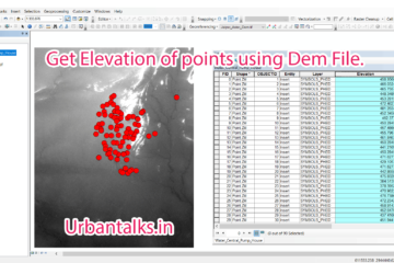
Summary – Get Elevation of Points using Dem file. Instructions provided describe how to Get Elevation of Points using Dem files. Two Steps: Interpolate 3d for the layer Using a dem file. Get Elevations to attribute table using Calculate Geometry tool. Note : If you are facing any difficulty following this Read more…

By Ritwika Dasgupta, 3 years3 years ago
Food

Introduction to My Food Journey

There’s no love sincere than the love for FOOD!! My love for food was always there somewhere. My childhood memories are full of MasterChef episodes and various other cooking shows and I loved eating outside since always. But when I left home for college, my love for food was unraveled Read more…

By Ritwika Dasgupta, 3 years3 years ago
ads by google
Popular Posts
  • How To: Create a Ground w... Summary - Create a Ground water level map for India i... 6 views | by Sandy | posted on October 15, 2017
  • MAP-1 Vijayawada City Map... Vijayawada City Map Download Data Used in t... 5 views | by Sandy | posted on April 28, 2019
  • MAP-4 Kanpur City Map 28-... Kanpur City Map Download Data Used in this... 5 views | by Sandy | posted on April 28, 2019
  • Start editing on new Shapefile Digitization of data from... Summary - Create shapefiles or geotiff from a wms lin... 4 views | by Sandy | posted on November 9, 2017
  • GIS0009-2018.02.18-Origin-Destination-Matrix-In-Gis-The-Easy-Way-feature-image Origin Destination Matrix... Summary - Plotting Origin Destination Matrix In Gis T... 4 views | by Sandy | posted on February 18, 2018
Recent Posts
  • GIS0016 2019.09.04 Landuse Pixelation to Identify Major Landuse by Area in each Grid
  • MAP-5 Jaipur City Map 06-05-2019
  • MAP-4 Kanpur City Map 28-04-2019
Recent Comments
  • [ QGIS ] – Origin Destination Matrix – The Easy Way (QGIS 2.x and QGIS 3.x) | All Around GIS on Origin Destination Matrix In Gis The Easy Way
  • Sandeep Kumar on Mapping Damage to Structures From Hurricane Harvey in Harris County (Houston)
  • Sandeep Kumar on How To: Create a Ground water level map for India in arcgis using data downloaded from CGWD
Archives
  • September 2019
  • May 2019
  • April 2019
  • November 2018
  • October 2018
  • September 2018
  • July 2018
  • March 2018
  • February 2018
  • January 2018
  • December 2017
  • November 2017
  • October 2017
Categories
  • ARCGIS
  • Autocad
  • City Maps
  • DATA SCIENCE
  • Drones/UAV
  • Environment
  • Food
  • GIS
  • Landuse
  • Maps
  • Project Management
  • python
  • QGIS
  • Software
  • Transport
  • TUTORIALS
  • Uncategorized
  • Urban Planning
  • Water
Popular Posts
  • GIS0009-2018.02.18-Origin-Destination-Matrix-In-Gis-The-Easy-Way-feature-image Origin Destination Matrix... Summary - Plotting Origin Destination Matrix In Gis T... 20 views | by Sandy | under ARCGIS, GIS, Maps, Project Management, QGIS, Software, Transport, TUTORIALS, Urban Planning
  • MAP-2 Ahmedabad City Map... Ahmedabad City Map Download Data Used in th... 20 views | by Sandy | under City Maps, DATA SCIENCE, Maps, Urban Planning
  • How To: Create a Ground w... Summary - Create a Ground water level map for India i... 13 views | by Sandy | under ARCGIS, GIS, Software, TUTORIALS
  • MAP-4 Kanpur City Map 28-... Kanpur City Map Download Data Used in this... 12 views | by Sandy | under City Maps, DATA SCIENCE, Maps, Urban Planning
  • MAP-1 Vijayawada City Map... Vijayawada City Map Download Data Used in t... 12 views | by Sandy | under City Maps, DATA SCIENCE, Maps, Urban Planning
Calender for posts
January 2021
S M T W T F S
« Sep    
 12
3456789
10111213141516
17181920212223
24252627282930
31  

  • Home
  • Maps
  • Tutorials
  • Food
  • About Us
Hestia | Developed by ThemeIsle