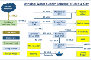
Urban Talks
  • Home
  • Maps
    • Vijayawada Land Prices Map
    • Amaravati Land Prices Map
  • Tutorials
    • GIS
  • Food
  • About Us

Sandy

TECH0003-2018.7.19-Host-Two-Webapps-on-Same-Server-Same-Port-Different-Domain-Name-Using-NGINX-0
Software

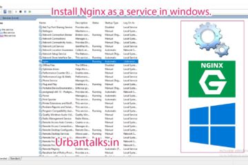
TECH0003 Install NGINX as a service on Windows

Summary – Install NGINX as a service on Windows. | NGINX | Host Two Web Apps on Same Server Same Port Different Domain Name Using NGINX. Two Steps: Download Nginx and NSSM. Use NSSM to install NGINX as  a service. Procedure Download NGINX and NSSM Download nginx from official download Read more…

By Sandy, 3 years3 years ago
TECH0002-2018.1.7-Host-Two-Webapps-on-Same-Server-Same-Port-Different-Domain-Name-Using-NGINX-0
Software

TECH0002 Host Two Web Apps on Same Server Same Port Different Domain Name Using NGINX

Summary – Host Two Web Apps on Same Server Same Port Different Domain Name Using NGINX. | NGINX | Host Two Web Apps on Same Server Same Port Different Domain Name Using NGINX. Two Steps: Start Your two or more Web Applications on two different internal ports. Setup NGINX Config Read more…

By Sandy, 3 years3 years ago
GIS0012-2018.07.11-Connect-Qgis-to-Postgis-Database-3.png
GIS

GIS0012 Connect Qgis to Postgis Database and Edit Data Layers

Summary – Connect Qgis to Postgis Database and Edit Data Layers. Instructions provided describe how to Connect Qgis to Postgis Database and Edit Data Layers. Two Steps: Connect Postgis Database to Qgis. Push back the edited data layer to Database. Procedure Connect Postgis Database to Qgis Add a Postgis database Read more…

By Sandy, 3 years3 years ago
GIS0009-2018.02.18-Origin-Destination-Matrix-In-Gis-The-Easy-Way-feature-image
ARCGIS

Origin Destination Matrix In Gis The Easy Way

Summary – Plotting Origin Destination Matrix In Gis The Easy Way. Instructions provided describe how to Plot Origin Destination matrix in Gis in an easy way. Two Steps: Prepare the Data needed for Plotting in GIS. Import data into QGIS Note : If you are facing any difficulty following this Read more…

By Sandy, 3 years2 years ago
GIS0009-2018.02.17-GIS-Features-Updation-using-Autocad-featured-image
ARCGIS

Update GIS Features using AutocadMap

Summary – Update GIS Features using AutocadMap. Instructions provided describe how to update GIS features using AutocadMap , in the tutorial AutocadMap 3D has been used to update a Shapefile. We all miss the good  cad interface when dealing with GIS data whether it be tracing or other tasks, this Read more…

By Sandy, 3 years3 years ago
Sample-of-Expression-of-Interest-in-a-Newspaper
Project Management

Sample Format for Expression of Interest and Minutes of Meeting

Sample Format for Expression of Interest in a Newspaper Download Editable Version Sample Notice inviting expression of interest Download Editable Version Sample Minutes of a Pre-Bid Meeting Download Editable Version

By Sandy, 3 years3 years ago
Drinking-water-supply-scheme-jaipur
Environment

Overview of Urban Water Management in Jaipur City

Jaipur water management at urban level is discussed below Importance of water in Indian cities as a resource Water is a fundamental natural resource to life and food security it is a finite and vulnerable resource, essential to sustain life, development and the environment, we will see below Jaipur water management. Water Read more…

By Sandy, 3 years3 years ago
TECH0001-2018.1.7-featured-image
Software

TECH 1 – Shared Folder between Windows host and linux guest on virtualbox

Summary – Shared Folder between Windows host and linux guest on virtualbox. Instructions provided describe how to create a Shared Folder between Windows host and linux guest on virtualbox. Three Steps: Change share folder settings in Virtual Box. Mount the Shared Folder in guest linux. Procedure 1. Change the share Read more…

By Sandy, 3 years3 years ago
Amaravati Map
Landuse

Want to explore the Future Landuse of Amaravati

Want to explore the Future Landuse of Amaravati, click on this URL. Original Website : GIS.APCRDA.ORG Amaravati LPS Map Published by GIS Department of APCRDA : https://gis.apcrda.org/lps/index.html Amaravati LPS Map Published by GIS Department of APCRDA : https://gis.apcrda.org/lps/index.html

By Sandy, 3 years2 years ago
Damage-to-Structures-From-Hurricane-Harvey-in-Harris-County-of-Houston
ARCGIS

Mapping Damage to Structures From Hurricane Harvey in Harris County (Houston)

Mapping damage from Hurricane Harvey in Harris County General Details Metadata of layers in MAP Source : Hcad Parcel and line Datasets, Fema National Flood Hazard Layer, U.S. Department of Housing and Urban Development Flood Extent Layer.

By Sandy, 3 years3 years ago

Posts navigation

Previous 1 2 3 Next
ads by google
Popular Posts
  • My College submission sheet for Landuse Transition Matrix Landuse Modeling for Chan... Summary - Create a Transition Matrix for Landuse Chan... 4 views | by Sandy | posted on November 9, 2017
  • MAP-4 Kanpur City Map 28-... Kanpur City Map Download Data Used in this... 3 views | by Sandy | posted on April 28, 2019
  • About Us Meet the Urbantalks Team Write something about the pe... 1 view | by Sandy | posted on August 29, 2017
  • GIS0012-2018.07.11-Connect-Qgis-to-Postgis-Database-3.png GIS0012 Connect Qgis to P... Summary - Connect Qgis to Postgis Database and Edit D... 1 view | by Sandy | posted on July 11, 2018
Recent Posts
  • GIS0016 2019.09.04 Landuse Pixelation to Identify Major Landuse by Area in each Grid
  • MAP-5 Jaipur City Map 06-05-2019
  • MAP-4 Kanpur City Map 28-04-2019
Recent Comments
  • [ QGIS ] – Origin Destination Matrix – The Easy Way (QGIS 2.x and QGIS 3.x) | All Around GIS on Origin Destination Matrix In Gis The Easy Way
  • Sandeep Kumar on Mapping Damage to Structures From Hurricane Harvey in Harris County (Houston)
  • Sandeep Kumar on How To: Create a Ground water level map for India in arcgis using data downloaded from CGWD
Archives
  • September 2019
  • May 2019
  • April 2019
  • November 2018
  • October 2018
  • September 2018
  • July 2018
  • March 2018
  • February 2018
  • January 2018
  • December 2017
  • November 2017
  • October 2017
Categories
  • ARCGIS
  • Autocad
  • City Maps
  • DATA SCIENCE
  • Drones/UAV
  • Environment
  • Food
  • GIS
  • Landuse
  • Maps
  • Project Management
  • python
  • QGIS
  • Software
  • Transport
  • TUTORIALS
  • Uncategorized
  • Urban Planning
  • Water
Popular Posts
  • My College submission sheet for Landuse Transition Matrix Landuse Modeling for Chan... Summary - Create a Transition Matrix for Landuse Chan... 25 views | by Sandy | under GIS, Landuse, QGIS, Software, TUTORIALS, Urban Planning
  • GIS0009-2018.02.18-Origin-Destination-Matrix-In-Gis-The-Easy-Way-feature-image Origin Destination Matrix... Summary - Plotting Origin Destination Matrix In Gis T... 21 views | by Sandy | under ARCGIS, GIS, Maps, Project Management, QGIS, Software, Transport, TUTORIALS, Urban Planning
  • MAP-4 Kanpur City Map 28-... Kanpur City Map Download Data Used in this... 21 views | by Sandy | under City Maps, DATA SCIENCE, Maps, Urban Planning
  • MAP-1 Vijayawada City Map... Vijayawada City Map Download Data Used in t... 17 views | by Sandy | under City Maps, DATA SCIENCE, Maps, Urban Planning
  • Drinking-water-supply-scheme-jaipur Overview of Urban Water M... Jaipur water management at urban level is discussed bel... 17 views | by Sandy | under Environment, Urban Planning, Water
Calender for posts
April 2021
S M T W T F S
« Sep    
 123
45678910
11121314151617
18192021222324
252627282930  

  • Home
  • Maps
  • Tutorials
  • Food
  • About Us
Hestia | Developed by ThemeIsle