Urban Talks
  • Home
  • Maps
    • Vijayawada Land Prices Map
    • Amaravati Land Prices Map
  • Tutorials
    • GIS
  • Food
  • About Us

soundex

DATASCIENCE-1-2018.11.28-SUPERFAST-FUZZY-JOIN-IN-PYTHON-USING-PANDAS-feature
DATA SCIENCE

DATASCIENCE-1-2018.11.28-SUPERFAST FUZZY JOIN IN PYTHON USING PANDAS

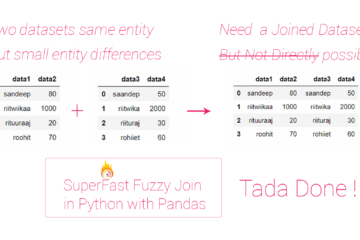
Summary – SUPERFAST FUZZY JOIN IN PYTHON USING PANDAS. Sometimes we have to join two different data set about same entities but variations in entity name, this makes direct join process incapable of handling the joins and results in mismatch. Here fuzzy join is handy as it uses soundex algorithm  to Read more…

By Sandy, 4 years4 years ago
ads by google
Popular Posts
  • MAP-1 Vijayawada City Map... Vijayawada City Map Download Data Used in t... 5 views | by Sandy | posted on April 28, 2019
  • MAP-5 Jaipur City Map 06-... Jaipur City Map Download Data Used in this... 3 views | by Sandy | posted on May 6, 2019
  • TECH0002-2018.1.7-Host-Two-Webapps-on-Same-Server-Same-Port-Different-Domain-Name-Using-NGINX-0 TECH0002 Host Two Web App... Summary - Host Two Web Apps on Same Server Same Port... 2 views | by Sandy | posted on July 18, 2018
  • MAP-4 Kanpur City Map 28-... Kanpur City Map Download Data Used in this... 2 views | by Sandy | posted on April 28, 2019
  • Start editing on new Shapefile Digitization of data from... Summary - Create shapefiles or geotiff from a wms lin... 2 views | by Sandy | posted on November 9, 2017
Recent Posts
  • Parking Development Cost Calculator by Krishna Kumar Srivastava
  • GIS0016 2019.09.04 Landuse Pixelation to Identify Major Landuse by Area in each Grid
  • MAP-5 Jaipur City Map 06-05-2019
Recent Comments
  • [ QGIS ] – Origin Destination Matrix – The Easy Way (QGIS 2.x and QGIS 3.x) | All Around GIS on Origin Destination Matrix In Gis The Easy Way
  • Sandeep Kumar on Mapping Damage to Structures From Hurricane Harvey in Harris County (Houston)
  • Sandeep Kumar on How To: Create a Ground water level map for India in arcgis using data downloaded from CGWD
Archives
  • June 2021
  • September 2019
  • May 2019
  • April 2019
  • November 2018
  • October 2018
  • September 2018
  • July 2018
  • March 2018
  • February 2018
  • January 2018
  • December 2017
  • November 2017
  • October 2017
Categories
  • ARCGIS
  • Autocad
  • City Maps
  • DATA SCIENCE
  • Drones/UAV
  • Environment
  • Food
  • GIS
  • Landuse
  • Maps
  • Project Management
  • python
  • QGIS
  • Software
  • Transport
  • TUTORIALS
  • Uncategorized
  • Urban Planning
  • Water
Popular Posts
  • Start editing on new Shapefile Digitization of data from... Summary - Create shapefiles or geotiff from a wms lin... 73 views | by Sandy | under ARCGIS, GIS, QGIS, Software, TUTORIALS
  • MAP-5 Jaipur City Map 06-... Jaipur City Map Download Data Used in this... 26 views | by Sandy | under Uncategorized
  • MAP-1 Vijayawada City Map... Vijayawada City Map Download Data Used in t... 19 views | by Sandy | under City Maps, DATA SCIENCE, Maps, Urban Planning
  • How To: Create a Ground w... Summary - Create a Ground water level map for India i... 12 views | by Sandy | under ARCGIS, GIS, Software, TUTORIALS
  • MAP-4 Kanpur City Map 28-... Kanpur City Map Download Data Used in this... 12 views | by Sandy | under City Maps, DATA SCIENCE, Maps, Urban Planning
Calender for posts
May 2023
S M T W T F S
« Jun    
 123456
78910111213
14151617181920
21222324252627
28293031  

  • Home
  • Maps
  • Tutorials
  • Food
  • About Us
Hestia | Developed by ThemeIsle